Monday, December 29, 2008
Monday, December 22, 2008
Tuesday, December 16, 2008

Sunday, December 14, 2008
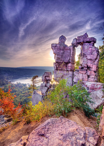
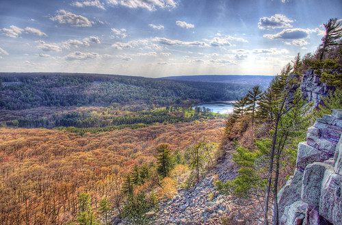
Gibraltar Rock Panorama
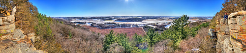
A roughly 180-degree panoramic, with myself on the far-right cliff for scale!
Friday, December 12, 2008

Thursday, December 11, 2008
Tuesday, December 2, 2008
Monday, December 1, 2008

Tuesday, November 25, 2008
Saturday, November 22, 2008

Tuesday, November 18, 2008

Saturday, November 15, 2008

Wednesday, November 12, 2008
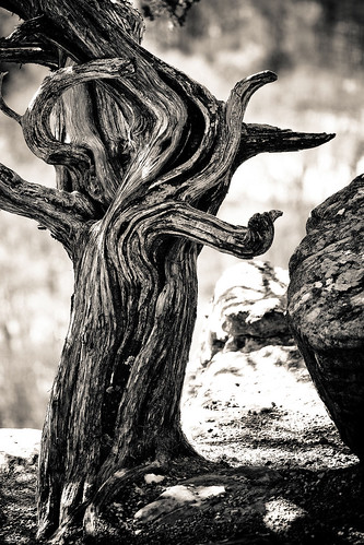
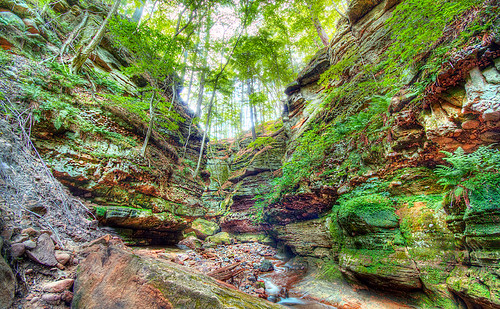
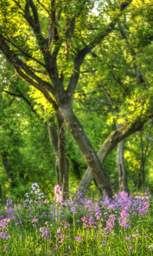
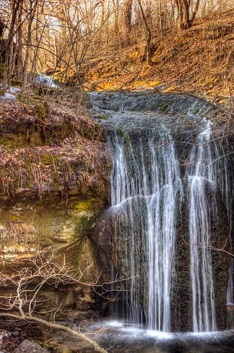
Pewits Nest State Natural Area
"The dominant feature at Pewits Nest is a 30- to 40-foot deep gorge formed during the retreat of the last glacier. Associated with it are Skillet Creek, shaded cliffs, and a northern dry-mesic forest. When Glacial Lake Baraboo drained, Skillet Creek cut a narrow canyon through the Cambrian sandstone, forming a series of potholes and waterfalls. The layers of Cambrian sandstone show that a finer-grained sediment was laid down by the Cambrian seas "inside" the syncline, a process different from that at Parfrey's Glen where coarser Cambrian conglomerates and sandstones are found in layers. Skillet Creek has a gradient of 38 feet/mile and an average flow of 0.8 cfs. Forest cover includes red cedar, white pine, hemlock, and yellow birch." -Wisc. DNR
Tuesday, November 11, 2008

Monday, November 10, 2008
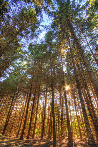
360-degree Forest Panorama
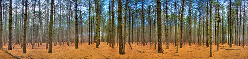
This one turned out really cool. It's a series of eight or ten HDR shots in the Gotham pine forest. When viewed full-size (about 60 megapixles) this is especially cool, or in an interactive Quicktime VR file. Shoot me a message or email if you want to check this out, and I'll send over the 2MB Quicktime file.
Gotham Jack Pine Barrens State Natural Area; Gotham, WI
Sunday, November 9, 2008
Friday, November 7, 2008
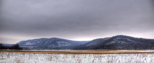
Pleasant Valley Sunset
Located in the Driftless Area of southwest Wisconsin, Pleasant Valley Conservancy sits on a long narrow ridge that runs almost due east/west, with steep hillsides facing both north and south. The site contains a nearly complete range of southern Wisconsin natural community types including oak woodland, oak savanna, dry and wet prairie, sedge meadow, shrub-carr, open marsh, and spring complex. The steep south-facing ridge supports several prairie remnants, which are now thriving after intensive management began in 1995. The oak savannas, primarily on the ridge top, contain numerous large, open-grown bur and white oaks with many being over 150 years old. The savanna supports numerous grass, sedge, and forb species including the state-endangered purple milkweed, which re-appeared after restoration and prescribed burning began. The cooler north-facing slope is predominantly oak woodland with red oak, basswood, hackberry, butternut, yellowbud hickory, and red maple. The savanna and oak woodland support a diversity of bird species which include the red-headed woodpecker, a declining bird species of conservation concern. Other birds include blue-gray gnatcatcher, eastern wood pewee, tufted titmouse, eastern bluebird, yellow-throated vireo, scarlet tanager, black-billed cuckoo, and yellow-billed cuckoo. Also present is the spring-fed Pleasant Valley Creek, which flows through the wetland and into East Blue Mounds Creek. Pleasant Valley Conservancy is owned in part by The Prairie Enthusiasts and by Tom and Kathie Brock with management support from the Savanna Oak Foundation, Inc.. It was designated a State Natural Area in 2007.

Derived from dnr.wi.gov/org/land/er/sna/sna551.htm
Sunday, November 2, 2008
Wednesday, October 29, 2008
Monday, October 27, 2008
Sunday, October 5, 2008
Tuesday, September 30, 2008
Sunday, September 28, 2008

Monday, September 22, 2008
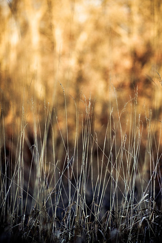
Superior Shore Grass
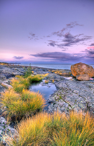
A lone boulder sits on the edge of this billion year-old basalt cliff - deposited here by glaciers during the last ice-age. Robust grasses grow alone so close to the waters edge, as this particular area lacks soil and nutrients to support larger plants. Any soil which does accumulate is lost to the effects of water and ice during harsh periods of storm and wave action along the shore.
Tuesday, September 16, 2008
Superior Shoreline

One-billion year old lava flows from the expansion of the Superior basin still reside in their basaltic form along the northern shore of Lake Superior.
Taken at Gooseberry Fall's State Park in Minnesota over Labor Day 2008.
Saturday, September 13, 2008
Split Rock Lighthouse State Park
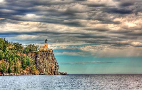
"Split Rock Lighthouse State Park is a Minnesota state park on the north shore of Lake Superior. It is best known for the picturesque Split Rock Lighthouse, which was built by the United States Lighthouse Service in 1910. The lighthouse and some adjacent buildings have been restored and the Minnesota Historical Society operates them as a museum. The park also offers scenic hiking, cross-country skiing, and bike trails. There is also a small campground with 22 cart-in tent sites (no vehicle access)." - Wikipedia
Monday, September 8, 2008
Golden Pines
The August sun breaks through a thick stand of pine tree's along the shoreline of this dried up post-glacial lake - Steinke Basin.
Tuesday, September 2, 2008
Devils Tower National Monument
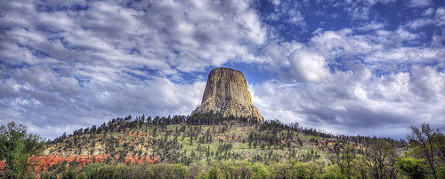
"Geologists agree that the igneous material intruded and then cooled as phonolite porphyry, a light to dark-gray or greenish-gray igneous trachyte rock with conspicuous crystals of white feldspar. As the lava cooled, hexagonal (and sometimes 4-, 5-, and 7-sided) columns formed. As the rock continued to cool, the vertical columns shrank horizontally in volume and cracks began to occur at 120 degree angles, generally forming compact 6-sided columns. Superficially similar, but with typically 2 feet (0.61 m) diameter columns, Devils Postpile National Monument and Giant's Causeway are columnar basalt." -Wikipedia
Monday, August 25, 2008
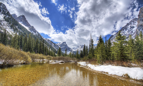
Death Canyon: Teton National Park
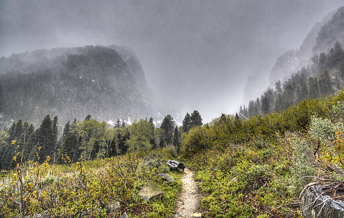
Following the trail into Death Canyon on a cold and sleeting afternoon. Massive U-shaped valleys such as this one (and most others in the Tetons) were carved by glaciers during past ice-ages.
Tuesday, August 19, 2008
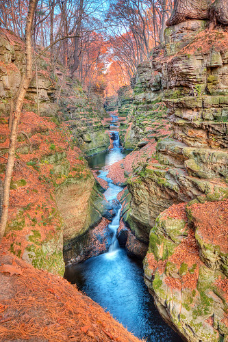
Moss Covered Canyon Walls
Taken at the flood damaged canyon of Parfrey's Glen.
Full set: http://flickr.com/photos/crisp_air/sets/72157606728548586/
Sunday, August 17, 2008
Tuesday, August 12, 2008
Mammatus Lake Cover
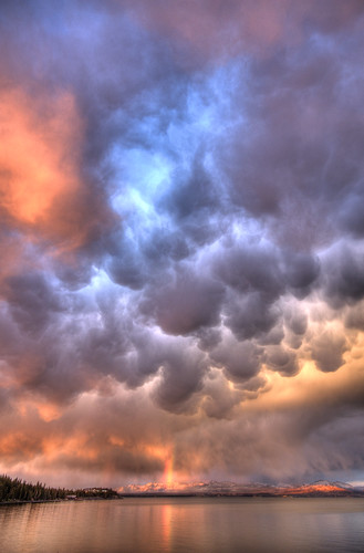
A spectacular view across Yellowstone Lake under cover of thick mammatus clouds. Mount Chittenden is visible miles away under the rainbow and cast in the suns final light.
Friday, August 8, 2008
Tuesday, August 5, 2008
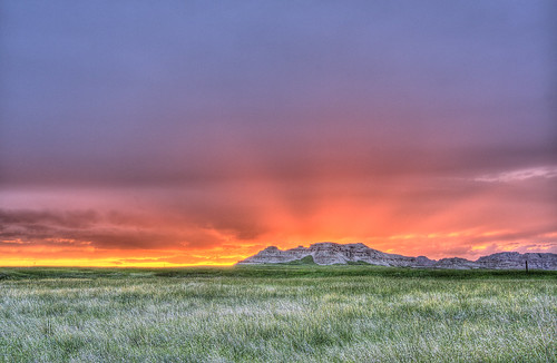
Badlands National Park: South Dakota
Please visit this set at the link below, which covers a road trip and camping in and through Yellowstone and Grand Teton National Parks, Devil's Tower National Monument, Cascade and Death Canyons, Big Horn Mountains, and more!
http://www.flickr.com/photos/crisp_air/sets/72157606036642501/
Thursday, July 31, 2008
Monday, July 28, 2008
Grand Canyon of The Yellowstone
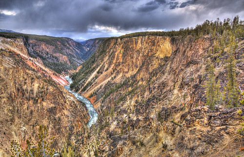
"The canyon below the Lower Yellowstone Falls was at one time the site of a geyser basin that was the result of rhyolite lava flows, extensive faulting, and heat beneath the surface (related to the hot spot). No one is sure exactly when the geyser basin was formed in the area, although it was probably present at the time of the last glaciation. The chemical and heat action of the geyser basin caused the rhyolite rock to become hydrothermally altered, making it very soft and brittle and more easily erodible (sometimes likened to baking a potato). Evidence of this thermal activity still exists in the canyon in the form of geysers and hot springs that are still active and visible. The Clear Lake area, which is fed by hot springs, south of the canyon is probably also a remnant of this activity. According to Ken Pierce, U.S. Geological Survey geologist, at the end of the last glacial period, about 14,000 to 18,000 years ago, ice dams formed at the mouth of Yellowstone Lake. When the ice dams melted, a great volume of water was released downstream causing massive flash floods and immediate and catastrophic erosion of the present-day canyon. These flash floods probably happened more than once. The canyon is a classic V-shaped valley, indicative of river-type erosion rather than glaciation. Today the canyon is still being eroded by the Yellowstone River." -Wikipedia
Tuesday, July 1, 2008
Pheasant Branch Nature Conservancy
A quick snap on a bike ride around the Pheasant Branch Nature Conservancy on May 28, 2008
Monday, June 2, 2008
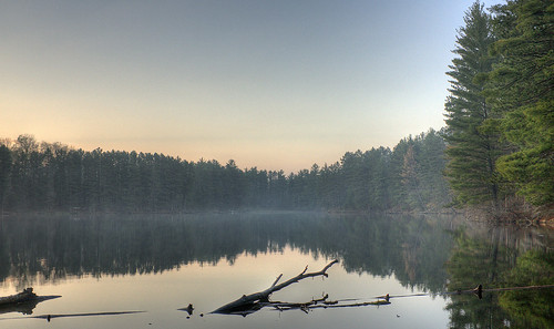
After the Rain
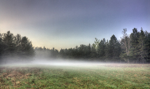
A blanket of fog rolled in following a surprise bout of afternoon rain showers.
-Chequamegon National Forest Region; Northwoods Wisconsin
Wednesday, May 21, 2008
Wednesday, May 7, 2008
Grand View
Looking West towards Devil's Lake on a perfect day from the The Ice Age Trail National Scenic Trail on the Eastern part of the Baraboo Range.
Monday, April 28, 2008
Countryside Rays
Taken enroute to Governor Dodge State Park in the driftless zone of southern Wisconsin. Note the stands of three different tree species along the bottom of this shot.
This sunny Friday was particularly humid due to warm temperatures and excessive snow meltoff, which produced well contrasted rays of light beneath the clouds.
Sunday, April 20, 2008
Stephens Falls
Stephens Falls is one of the few natural waterfalls in Southern Wisconsin.
-Governor Dodge State Park
Tuesday, April 15, 2008
Helena Unit Lower Wisconsin State Riverway
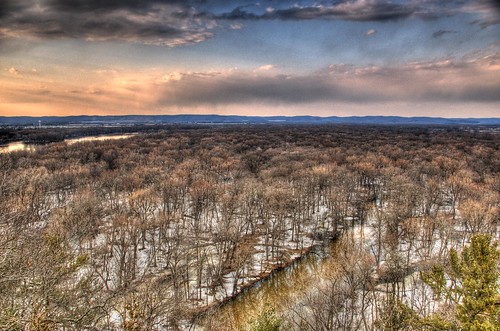
Helena Unit Lower Wisconsin State Riverway viewed from the Shot Tower and Smelter House at Tower Hill State Park.
The Spring Green water tower is visible on the opposite side of the Wisconsin River on the left-hand side of this photo.
The hills visible in the distance mark the edge of the flat, ancient Wisconsin River floodplain which cut through the hills of the Driftless Zone over the span of several ice ages.
Sunday, March 30, 2008
Wednesday, March 26, 2008
Natures Cycle
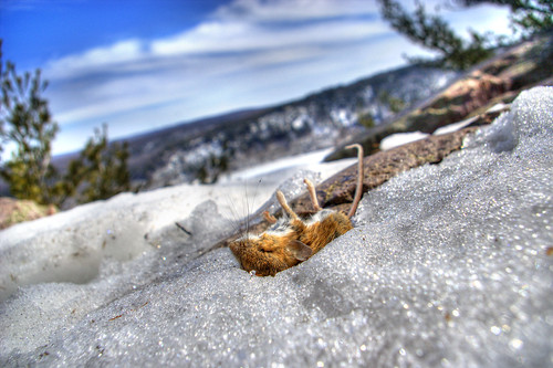
We noticed this perfectly dead mouse after pausing on an overlook for water and to catch a breath. This is one of several different angles I took of the critter, trying to capture the depth of the bluffs beyond and the brilliant blue sky... I'm sure this guy became quick lunch for a crow, vulture, hawk or land carnivore.
Friday, March 21, 2008
Tuesday, March 11, 2008
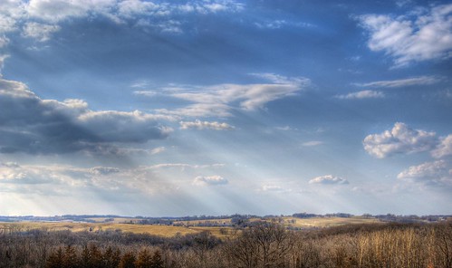
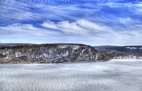
The Baraboo Range
The Baraboo Range consists of highly eroded precambrian metamorphic rock; and is about 25 miles long and varies from 5 to 10 miles in width.
The range is an example of a buried mountain range exposed through erosion, to once again undergo the forces of surface erosion. The rocks are as much as 1.6 billion years old, among the oldest exposed rocks in North America consisting mainly of pink Baraboo quartzite and red rhyolite.
The Wisconsin River, previously travelling in a north to south direction, turns to the east behind it before making its turn to the west towards the Upper Mississippi River. The eastern end of the range was glaciated during the Wisconsinian glaciation, while the western half was not, and consequently, marks the eastern boundary of Wisconsin's Driftless Area.
Wednesday, February 20, 2008
Positive Contrast

Bright fall foliage nicely contrasts this otherwise muted and foggy afternoon at Devil's Lake. A pilar of Baraboo purple quartzite towers nearly 500 feet above the lake's surface.
Subscribe to:
Posts (Atom)