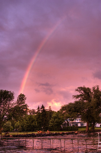
Rainbows can be observed whenever there are water drops in the air and sunlight shining from behind the observer at a low altitude or angle. Although more rare, a moonbow, or lunar rainbow, can be seen on strongly moonlit nights. However since human visual perception for color is poor in low light, moonbows are most often perceived to be white.
The rainbow's appearance is caused by dispersion of sunlight as it goes through raindrops. The light is first refracted as it enters the surface of the raindrop, reflected off the back of the drop, and again refracted as it leaves the drop. The overall effect is that the incoming light is reflected back over a wide range of angles, with the most intense light at an angle of 40°–42°. The angle is independent of the size of the drop, but does depend on its refractive index, or how much a material bend's light which passes through it's boundary. Seawater has a higher refractive index than rain water due to salt minerals, so the radius of a 'rainbow' in sea spray is smaller than a true rainbow. This is visible to the naked eye by a misalignment of these bows.
A rainbow does not actually exist at a particular location in the sky. It is, instead, an optical phenomenon whose apparent position depends on the observer's location and the position of the sun. A rainbow does not actually exist at a particular location in the sky. It is, instead, an optical phenomenon whose apparent position depends on the observer's location and the position of the sun.
Thursday, May 31, 2007
Optical Phenomena
Tuesday, May 29, 2007
Fire in the Sky
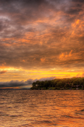
The red color in the sky at sunset (and sunrise) is due to an effect called Rayleigh scattering. There is a similar form of scattering called Mie scattering, which is responsible for the white color of clouds.
Particles in our atmosphere that are approximately the same size as the wavelength of visible light cause the white light from the sun to scatter and split into individual components. Oxygen and Nitrogen (the main components of our atmosphere) scatter violet and blue light due to their small size. This is why the sky appears to be blue in the daytime, especially at mid-day when the Sun is closest to us.
During sunrise and sunset the distance that the light has to travel from the Sun to an observer is at its greatest. This means the a large amount of blue and violet light has been scattered so the light that is received by an observer is mostly of a longer wavelength and therefore appears to be red.
Thursday, May 24, 2007
Wednesday, May 23, 2007
Non-functional Windmill
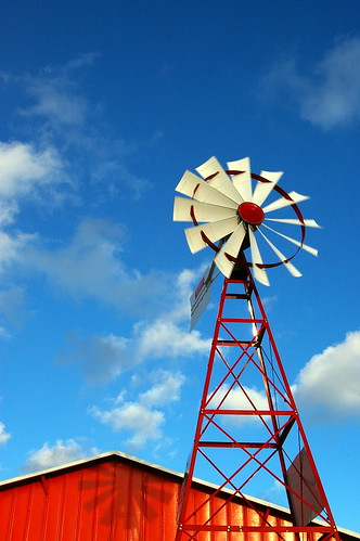
This was a cool shot and I was surprised how nicely it came out despite the fact it was just a quick snap out the mini-van window while stuck in traffic in Fort Wayne, Indiana.
As for a little known (or unknown) history on Fort Wayne, the city has historically served as a transportation and communications hub due to the fact it's nearly equidistant from Chicago, Cincinnati, and Detroit and has served as an incubator for many companies and products.
Fort Wayne is named after Gen. "Mad" Anthony Wayne. The United States Army built this last in a series of forts near the community of Kekionga, the largest of all Miami villages (the Miami nation established the first settlement in the mid-17th Century), which is located where the St. Joseph River and St. Mary's River join to form the Maumee River.
Beside its "Summit City" nickname, Fort Wayne also is informally called the "City of Churches" by some of its residents; a nickname that stretches back to the late 1800s when the city was the hub of regional Catholic and Lutheran faiths. Until the building of the Lincoln Bank Tower in 1929, church and cathedral spires dominated the city's skyline. Fort Wayne is also known as the "City of Restaurants" (with over 600 in and around the city) - and serves as a sort of "testing grounds" for new franchises before branching out across the country.
Tuesday, May 22, 2007
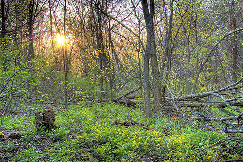
Blue Mound State Park
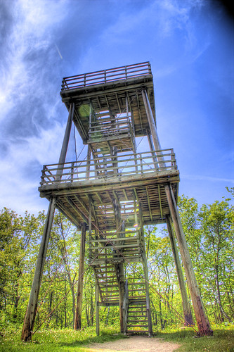
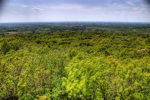
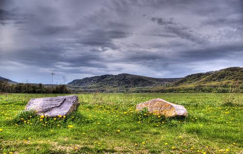
After hiking nearly an hour through dense woods at Blue Mound State Park, the trees lifted and skies widened.
Blue Mound State Park is the highest point in Southern Wisconsin. 2-billion years ago this area comprised the “roots” of an ancient mountain range and gradually, these mountains were eroded down to rolling granite plains wind, rain, ice, and inland sea's.
As Wisconsin terrain warped up and down repeatedly, extensive inland oceans alternately flowed into and retreated from the area. In the process, sand and soft limy sediments were deposited on top of the granite. The first sea covered the area more than 1 billion years ago, and the last (the Silurian Sea) about 400 million years ago.
Eons of cementation and pressure changed the sands and limy sediments into sandstone’s and limestone’s. Most of Wisconsin, Illinois, Iowa, and Minnesota once looked much the same until a series of four glaciers inched their way across the North America thousands of years ago. Massive sheets of ice peeled off hilltops and filled in valleys from Canada to Kansas, leaving a vast, flat expanse in their wake.
Due to certain geological quirks of fate, southwestern Wisconsin was bypassed and encircled by the four glaciers. The area, therefore, stands as an island of hills and valleys amid surrounding plains. The term “Driftless Area” is given to this region because it is devoid of drift or the accumulated rock and soil left by retreating glaciers.
Friday, May 18, 2007
Kangaroo
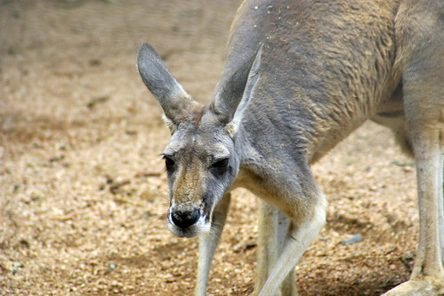
If you didn't know, kangaroo's have long been regarded as strange animals. Early Australian explorers described them as creatures that had heads like deer (though without antlers), stood upright like men, and hopped like frogs!
Like all marsupials, female kangaroos have a pouch called a marsupium in which joeys complete postnatal development. Kangaroo's are also the only large animal to use hopping as a means of locomotion. Comfortable speeds are around 15mph, but speeds up to 44mph can be attained for short distances. Also, because of large feet, kangaroo's can't walk, but instead must use their muscular tail to form a tripod to move at slow speeds.
This photo is part of a much larger set from the Atlanta Zoo; which is also part of a 5-set collection documenting a trip last summer tourinbg New Orleans and the Gulf of Mexico.
You can see the collection here: http://flickr.com/photos/crisp_air/collections/72157600176131056/
Cheers!
Thursday, May 17, 2007
Exit Here!
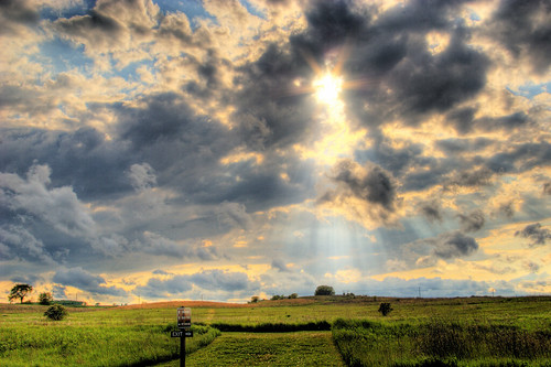
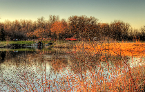
After shooting a full set of HDR photos at local Governor Nelson state park on the way home from work (and following heavy spring thunder-showers), I had to snap off one last picture from my car window on the drive out.
Ironically, the "Exit -->" sign points directly to the beam of sunlight!
Wednesday, May 16, 2007
Tuesday, May 15, 2007
In Flight
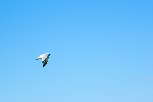
This photo come's from a set of shot's taken last September while out boating on Lake Mendota, here in Madison, WI.
Not much more to say about this photo other than I really liked how attention is drawn to this bird. If there had been a cloud in the background it could've easily ruined this frame.
Monday, May 14, 2007
Aztalanian Warfare
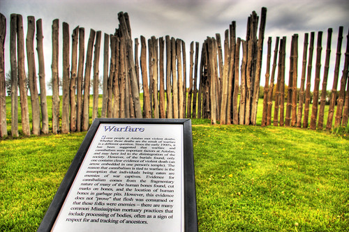
"Indian people lived at Aztalan between 900 and 1200 CE. The village encompassed 20 acres and was well-planned. The inhabitants planted corn, beans and squash, hunted wild game, fished and collected native plants for food. An elite group of individuals organized ceremonies and village life. A stockade surrounded the major portion of the villade. Inside, three platform mounds and a natural knoll marked four corners of a large plaza. The village was abandoned for reasons that remain a mystery.
Aztalan is one of the most important archeological sites in Wisconsin, representing a complex life-style rarely found in the Great Lakes region: a unique blend of native and exotic cultures. Information about the site was first published in 1836, and since then the ruins have attracted considerable public and scientific interest. Archeological excavations continue to uncover valuable information about Aztalan's daily life."
Taken from the current 1991 official historical site marker at Aztalan State Park, near Lake Mills, Wisconsin.
Friday, May 11, 2007
Climber Rescue
When I arrived at Devils Lake, I was going to hike along the right side of the lake, however there was a rescue going on with several emergency vehicles - and if you view the full-size version of this shot you can see several people carrying a person out on a stretcher along the water-front. As they loaded this individual into the ambulance I could hear him yelling from across the lake.
A lot of people attempt to free climb these boulders, and every year many are injured and require rescue, and a few die.
Devil's Lake State Park is located in Baraboo, Wisconsin (just 40 miles northwest of Madison, and is situated along the Ice Age National Scientific Reserve. The nearly-10,000-acre park is home to more than 1.3 million visitors each year and has two large sandy beaches, camping, boating, hiking, fishing, and 500-foot high bluffs.
Originally as the glacier pushed and cut through the land, it piled up these hills. After the recession of ice and over the course of about 15,000 years, the soil and smaller rocks on these bluffs has been erroded away and fully exposed these exceptionally hard Baraboo Quartzite boulders.
Thursday, May 10, 2007
Lightning Reflections
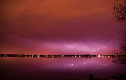
Looking South over Lake Monona, the mirror-like lake seemingly doubles the impact of lightning bolts. Heavy, lightning laden storms are common in this part of the country during spring and summer months. This particular hail based storm system was moving to West to East just South of Madison, and thankfully missed us completely without even giving much more than a breeze.
What may seem like a single lightning strike actually "re-strikes" the same object an average of 8 to 12 times repeatedly, and is what causes the "strobe light" effect we're familiar with. A single bolt of lightning can travel at a speed of 100,000 mph, and can reach temperatures approaching 50,000°F with roughly one billion volts of electricity - enough to fuse sand into columns of glass.
On average lightning strikes the Earth 100 times a second.
Tuesday, May 8, 2007
The Next Generation
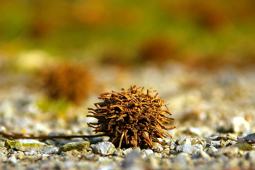
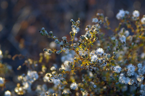
Sometimes it is the smallest objects in nature that create an opportunity for a formidable photo.
These seeds of unknown origin (anyone know?) were scattered everywhere at Fox Island Nature Reserve, in Fort Wayne, Indiana. Employing the 'sit-the-camera-on-the-ground-and-take-a-picture' technique, along with a short 18mm lens, some great lighting, and a little luck - this shot captures in extreme detail what may go un-noticed by many.
Monday, May 7, 2007
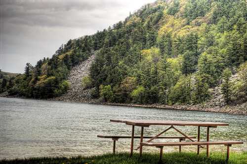
Glacial Sculpting
Just 15,000 years ago, during the last Ice Age, most of northern North America was trapped under the grip of colossal ice sheets. No where else in the U.S. are glacial marks on the land more visible than in Wisconsin. This last period over which 2/3 of the state was under ice, lasted from about 100,000 to 10,000 years ago. Amazingly, the ice sheet crept from northwestern just 10,000 years ago back into Canada.
In a sense, this region of the state is still recovering from the melting of the last glacier. As streams slowly wash away kames, eskers, moraines, and other glacial features, and as marshes, bogs, and lakes fill with sediment and organic debris, this young landscape will become transformed again long after man kind leaves the area.
Wisconsin’s legacy from the glaciers and meltwater streams of the last Ice Age is a landscape of great diversity and beauty. Wisconsin's many lakes and ponds, forested hills and ridges, and rolling farmlands remind us of a past glacier’s visit , and serve as a sign that once again everything around this area will be under a mile-high slab of ice.
Saturday, May 5, 2007
Rebuilding New Orleans

This post may be slightly against the "Crisp Air" motto of containing nothing but nature shots, but I thought this shot needed highlighted.
Shot from the Lower Ninth Ward in New Orleans just 12 months after Katrina, you can clearly see the state of disrepair that this area was in. Notice the height of the water level above the man - this brown line of sewage, petrol products and waste was visible throughout the entire New Orleans area, and one could easily decipher how far below sea level each individual home or business was.
Thursday, May 3, 2007
HDR Creek Painting
This photo was shot at a local park just North of Madison, called Tolken Creek. This Dane County park contains a creek which flows approximately 10,000 gal/sec and provides ~90% of the water which flows into our local system of lakes.
This shot is a favorite of mine not only because of the multiple objects in motion, but also because of the painted quality of colors, saturations, and contrasts. In one exposure, a fish jumped from the pond. In another, a red truck drove past. The saturated orange light on the marsh grasses is actually direct sunlight, and this photo was taken about 25 minutes before sundown.
In order to fully appreciate this image, it's best viewed by clicking on the photo directly (which takes you to the photo's Flickr page), and then click the "All Sizes" button and view the largest size.
Tuesday, May 1, 2007
The First Stage
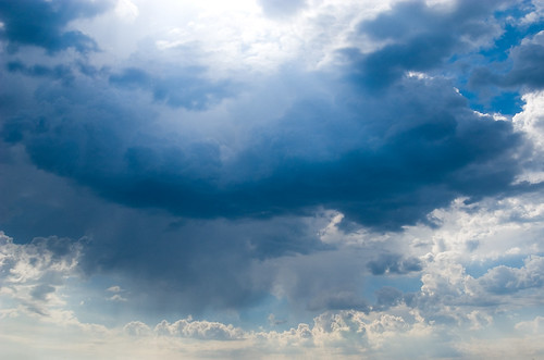
Almost appearing heavenly, the sun breaks through the rear of another small cell passing overhead. This single storm brought just sprinkles to my position (which are visible as falling bands just underneath the base), however just 30 minutes later this contained a substantial updraft, dumping 1/2" hail in Eastern counties and land.
Cloud Scape
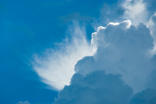
A clear blue morning was interupted by a very small chain of developing cells. In Middleton, Wi (where I work) we wen't hit directly by any means - though we did get about 15 minutes of hard rain and some decent wind gusts.
This photo was shot of a cloud top being sheared away by upper-level jet stream winds.